






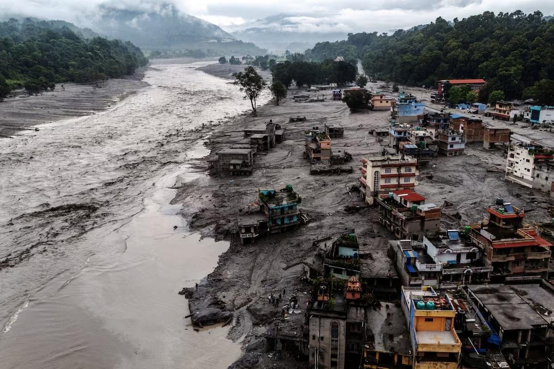
ASIA - The devastating flash floods that swept through parts of Nepal on August 26, 2026, have left hundreds dead and more than 1,300 people missing, after torrents of water, ice, rocks, and mud tore through communities along the Nepal-China border.
While flash floods are often associated with intense rainfall, scientists investigating this disaster believe the event may have had a very different origin: a massive collapse of glacial ice and rock high in the Himalayas.
The exact sequence of events is still being investigated. Still, scientists tell ABC News that evidence gathered so far points to a chain reaction involving a glacier collapse, landslides and a powerful flood wave.
A Collapse High in the Himalayas
The first signs of the disaster emerged at around 8:37 a.m. local time, when powerful ground shaking was detected near the Nepal-China border, north of Kathmandu.
An automated US Geological Survey system initially identified the shaking as an earthquake. Scientists later determined that it was likely caused by a huge glacier collapse and debris flow, producing energy equivalent to a magnitude 5.2 earthquake.
Satellite images taken before and after the event show that a large section of glacier broke away from a mountain and plunged toward the river below.
Scientists estimate that the ice travelled roughly about 2.1 km downhill, with the collapsed section measuring around 610 meters wide.
A landslide appears to have occurred at the same time, sending enormous quantities of rock and ice down the mountainside and into the Lhende Khola River, a tributary of the Bhote Koshi River.
How Ice and Rock Became a Flood
The collapse did not simply send a pile of ice and rocks into the valley. The enormous energy generated as the material moved rapidly downhill may have helped melt some of the ice.
As the torrent travelled toward the river, it also picked up water and sediment, increasing its size and destructive power.
Daniel Shugar, a geologist at the University of Calgary, told CNN that this process could explain the extraordinary amount of water seen rushing through the narrow mountain valleys.
The resulting flood wave was a mixture of water, pulverized ice, mud and rock.
According to Jeffrey Kargel, a senior scientist at the Planetary Science Institute, the wave travelled the first 22 kilometers at an average speed of around 193 kilometers per hour. At that speed, it covered nearly 14 miles in less than seven minutes.
The combination of speed, height and debris helps explain why the flooding caused such extensive destruction.
Why Climate Change Matters
Scientists caution that climate change cannot automatically be identified as the sole cause of a particular landslide or glacier collapse. Such events can occur naturally in mountainous regions.
However, a warming climate is changing the conditions in which these hazards occur.
The Hindu Kush Himalaya region, which includes Nepal, is warming rapidly. Its glaciers are losing ice, while melting and changing temperatures can contribute to instability in high-altitude environments.
Recent research has found that glacier ice loss rates across the Hindu Kush Himalaya have doubled since 2000.
Wouter Buytaert, a hydrology professor at Imperial College London, described the disaster as the type of event that climate change can intensify, noting that warming temperatures shrink glaciers and can make them more vulnerable to breaking apart
A Region Already Vulnerable to Glacial Floods
The disaster is not an isolated event in the Himalayan region.
In July 2025, the Bhote Koshi River suddenly surged after what Nepal's Department of Hydrology and Meteorology determined was a glacial lake outburst in the Lhende River area near the Nepal-China border.
The Himalayas contain thousands of glaciers and glacial lakes, some of which pose risks to communities downstream.
A study by the International Centre for Integrated Mountain Development and the United Nations Development Programme identified 3,624 glacial lakes across Nepal, India and Tibet. Forty-seven were classified as potentially dangerous, including 21 in Nepal.
Why Early Warning Is So Difficult
One of the biggest challenges highlighted by the disaster is that not all flash floods can be forecast through conventional weather monitoring.
No forecast before the disaster predicted an avalanche or glacier collapse at this particular location.
Scientists also warned that the initial collapse may have destabilized surrounding slopes. A second landslide reportedly occurred around three hours after the first event.
Mud and debris may also have blocked sections of river channels, creating temporary dams that could later collapse and produce additional flooding.
As scientists continue studying satellite imagery, seismic data and conditions on the ground, one question remains central: where did the enormous volume of water come from?
The answer could help researchers better understand the disaster and improve early-warning systems for communities living downstream of the Himalayas.
For Nepal, where thousands of people live in valleys beneath unstable mountains and glaciers, understanding these increasingly complex chains of hazards is becoming an urgent matter of disaster preparedness.